| at: |
Lake Russell WMA |
Data from Positive Flow
 show on map
 animate
Trail users:


Elevation Profile
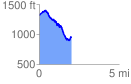
 2.069293 mi
 307.10 ft
 651.04 ft
 -343.94 ft
 5.96 %
GPX Downloads: Track Route
![]()
| at: |
Lake Russell WMA |
show on map
animate
2.069293 mi
307.10 ft
651.04 ft
-343.94 ft
5.96 %