|
| at: |
Locust Stake |
Data from USFS GIS
 show on map
 animate
Trail users:


Elevation Profile
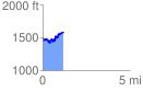
 1.212552 mi
 327.43 ft
 253.54 ft
 73.89 ft
 5.11 %
GPX Downloads: Track Route
![]()
|
| at: |
Locust Stake |
show on map
animate
1.212552 mi
327.43 ft
253.54 ft
73.89 ft
5.11 %