| at: |
Lake Russell WMA |
Data from USFS GIS
 show on map
 animate
Trail users:

Elevation Profile
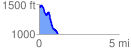
 1.200664 mi
 223.64 ft
 660.31 ft
 -436.67 ft
 10.42 %
GPX Downloads: Track Route
![]()
| at: |
Lake Russell WMA |
show on map
animate
1.200664 mi
223.64 ft
660.31 ft
-436.67 ft
10.42 %