| at: |
Cohutta Wilderness |
Data from USFS GIS
 show on map
 animate
Trail users:


Elevation Profile
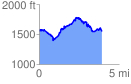
 3.976001 mi
 2132.69 ft
 2154.72 ft
 -22.03 ft
 10.26 %
GPX Downloads: Track Route
![]()
| at: |
Cohutta Wilderness |
show on map
animate
3.976001 mi
2132.69 ft
2154.72 ft
-22.03 ft
10.26 %