| at: |
Cohutta Wilderness |
Data from USFS GIS
 show on map
 animate
Trail users:

Elevation Profile
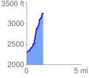
 1.562972 mi
 1052.77 ft
 66.29 ft
 986.48 ft
 12.76 %
GPX Downloads: Track Route
![]()
| at: |
Cohutta Wilderness |
show on map
animate
1.562972 mi
1052.77 ft
66.29 ft
986.48 ft
12.76 %