| at: |
Cohutta Wilderness |
Data from USFS GIS
 show on map
 animate
Trail users:


Elevation Profile
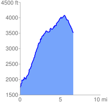
 6.742619 mi
 2886.89 ft
 1144.47 ft
 1742.42 ft
 8.11 %
GPX Downloads: Track Route
![]()
| at: |
Cohutta Wilderness |
show on map
animate
6.742619 mi
2886.89 ft
1144.47 ft
1742.42 ft
8.11 %