| at: |
Cohutta Wilderness |
Data from USFS GIS
 show on map
 animate
Trail users:


Elevation Profile
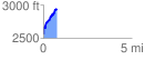
 0.764086 mi
 447.25 ft
 82.10 ft
 365.15 ft
 11.09 %
GPX Downloads: Track Route
![]()
| at: |
Cohutta Wilderness |
show on map
animate
0.764086 mi
447.25 ft
82.10 ft
365.15 ft
11.09 %