| at: |
Cohutta Wilderness |
Data from USFS GIS
 show on map
 animate
Trail users:


Elevation Profile
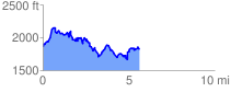
 5.744224 mi
 1633.99 ft
 1690.92 ft
 -56.93 ft
 5.58 %
GPX Downloads: Track Route
![]()
| at: |
Cohutta Wilderness |
show on map
animate
5.744224 mi
1633.99 ft
1690.92 ft
-56.93 ft
5.58 %