| at: |
Cohutta Wilderness |
Data from USFS GIS
 show on map
 animate
Trail users:

Elevation Profile
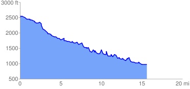
 15.965006 mi
 3534.34 ft
 5152.36 ft
 -1618.02 ft
 6.11 %
GPX Downloads: Track Route
![]()
| at: |
Cohutta Wilderness |
show on map
animate
15.965006 mi
3534.34 ft
5152.36 ft
-1618.02 ft
6.11 %