| at: |
Lake Conasauga Recreation Area |
Data from USFS GIS
 show on map
 animate
Trail users:

Elevation Profile
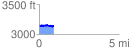
 0.904124 mi
 103.58 ft
 104.23 ft
 -0.65 ft
 2.18 %
GPX Downloads: Track Route
![]()
| at: |
Lake Conasauga Recreation Area |
show on map
animate
0.904124 mi
103.58 ft
104.23 ft
-0.65 ft
2.18 %