| at: |
Cohutta Wilderness |
Data from USFS GIS
 show on map
 animate
Trail users:

Elevation Profile
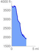
 3.070418 mi
 421.10 ft
 2275.30 ft
 -1854.20 ft
 14.03 %
GPX Downloads: Track Route
![]()
| at: |
Cohutta Wilderness |
show on map
animate
3.070418 mi
421.10 ft
2275.30 ft
-1854.20 ft
14.03 %