| at: |
Cohutta Wilderness |
Data from USFS GIS
 show on map
 animate
Trail users:


Elevation Profile
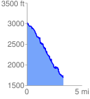
 3.382610 mi
 506.83 ft
 1866.68 ft
 -1359.86 ft
 10.45 %
GPX Downloads: Track Route
![]()
| at: |
Cohutta Wilderness |
show on map
animate
3.382610 mi
506.83 ft
1866.68 ft
-1359.86 ft
10.45 %