| at: |
Brawley Mountain |
Data from USFS GIS
 show on map
 animate
Trail users:

Elevation Profile
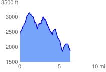
 6.497740 mi
 1955.25 ft
 2593.92 ft
 -638.68 ft
 7.56 %
GPX Downloads: Track Route
![]()
| at: |
Brawley Mountain |
show on map
animate
6.497740 mi
1955.25 ft
2593.92 ft
-638.68 ft
7.56 %