| at: |
Cohutta Wilderness |
Data from USFS GIS
 show on map
 animate
Trail users:


Elevation Profile
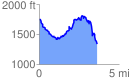
 3.680988 mi
 890.04 ft
 1294.72 ft
 -404.68 ft
 6.66 %
GPX Downloads: Track Route
![]()
| at: |
Cohutta Wilderness |
show on map
animate
3.680988 mi
890.04 ft
1294.72 ft
-404.68 ft
6.66 %