| at: |
Cohutta Wilderness |
Data from USFS GIS
 show on map
 animate
Trail users:


Elevation Profile
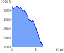
 6.707431 mi
 879.18 ft
 2988.43 ft
 -2109.25 ft
 8.44 %
GPX Downloads: Track Route
![]()
| at: |
Cohutta Wilderness |
show on map
animate
6.707431 mi
879.18 ft
2988.43 ft
-2109.25 ft
8.44 %