| at: |
Cohutta Wilderness |
Data from USFS GIS
 show on map
 animate
Trail users:

Elevation Profile
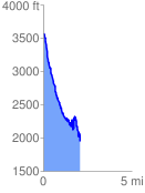
 2.117096 mi
 788.78 ft
 2392.39 ft
 -1603.61 ft
 21.40 %
GPX Downloads: Track Route
![]()
| at: |
Cohutta Wilderness |
show on map
animate
2.117096 mi
788.78 ft
2392.39 ft
-1603.61 ft
21.40 %