| at: |
Iron Mountain/Sumac Creek |
Data from USFS GIS
 show on map
 animate
Trail users:


Elevation Profile
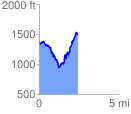
 2.437681 mi
 972.73 ft
 873.22 ft
 99.51 ft
 7.56 %
GPX Downloads: Track Route
![]()
| at: |
Iron Mountain/Sumac Creek |
show on map
animate
2.437681 mi
972.73 ft
873.22 ft
99.51 ft
7.56 %