| at: |
Cohutta Wilderness |
Data from USFS GIS
 show on map
 animate
Trail users:

Elevation Profile
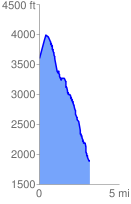
 3.224205 mi
 588.18 ft
 2309.61 ft
 -1721.43 ft
 13.57 %
GPX Downloads: Track Route
![]()
| at: |
Cohutta Wilderness |
show on map
animate
3.224205 mi
588.18 ft
2309.61 ft
-1721.43 ft
13.57 %