| at: |
Blue Ridge WMA |
Data from David Muse
 show on map
 animate
Trail users:

Elevation Profile
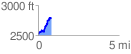
 0.837929 mi
 349.38 ft
 66.83 ft
 282.55 ft
 7.90 %
GPX Downloads: Track Route
Trailheads:
 AT - Three Forks
![]()
| at: |
Blue Ridge WMA |
show on map
animate
0.837929 mi
349.38 ft
66.83 ft
282.55 ft
7.90 %
AT - Three Forks