| at: |
North Oconee National Forest |
Data from USFS GIS
 show on map
 animate
Trail users:

Elevation Profile
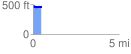
 0.501190 mi
 60.41 ft
 68.97 ft
 -8.56 ft
 2.61 %
GPX Downloads: Track Route
![]()
| at: |
North Oconee National Forest |
show on map
animate
0.501190 mi
60.41 ft
68.97 ft
-8.56 ft
2.61 %