| at: |
Warwoman WMA |
Data from USFS GIS
 show on map
 animate
Trail users:

Elevation Profile
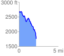
 2.180181 mi
 246.13 ft
 1126.98 ft
 -880.85 ft
 9.79 %
GPX Downloads: Track Route
![]()
| at: |
Warwoman WMA |
show on map
animate
2.180181 mi
246.13 ft
1126.98 ft
-880.85 ft
9.79 %