|
| at: |
Rabun Beach Recreation Area |
Data from USFS GIS
 show on map
 animate
Trail users:

Elevation Profile
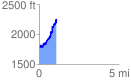
 1.099392 mi
 617.71 ft
 268.75 ft
 348.96 ft
 10.64 %
GPX Downloads: Track Route
![]()
|
| at: |
Rabun Beach Recreation Area |
show on map
animate
1.099392 mi
617.71 ft
268.75 ft
348.96 ft
10.64 %