|
| at: |
Coopers Creek WMA |
Data from David Muse
 show on map
 animate
Trail users:


Elevation Profile
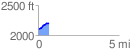
 0.651808 mi
 104.92 ft
 5.06 ft
 99.86 ft
 3.05 %
GPX Downloads: Track Route
![]()
|
| at: |
Coopers Creek WMA |
show on map
animate
0.651808 mi
104.92 ft
5.06 ft
99.86 ft
3.05 %