| at: |
Warwoman WMA |
Data from USFS GIS
 show on map
 animate
Trail users:

Elevation Profile
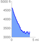
 4.041825 mi
 741.53 ft
 2072.91 ft
 -1331.39 ft
 9.71 %
GPX Downloads: Track Route
![]()
| at: |
Warwoman WMA |
show on map
animate
4.041825 mi
741.53 ft
2072.91 ft
-1331.39 ft
9.71 %