| at: |
Sandy Ford |
Data from USFS GIS
 show on map
 animate
Trail users:

Elevation Profile
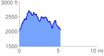
 5.542282 mi
 2137.09 ft
 2232.00 ft
 -94.91 ft
 7.63 %
GPX Downloads: Track Route
![]()
| at: |
Sandy Ford |
show on map
animate
5.542282 mi
2137.09 ft
2232.00 ft
-94.91 ft
7.63 %