| at: |
Warwoman WMA |
Data from USFS GIS
 show on map
 animate
Trail users:

Elevation Profile
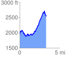
 3.406999 mi
 1610.65 ft
 1035.97 ft
 574.68 ft
 8.95 %
GPX Downloads: Track Route
![]()
| at: |
Warwoman WMA |
show on map
animate
3.406999 mi
1610.65 ft
1035.97 ft
574.68 ft
8.95 %