| at: |
Sandy Ford |
Data from USFS GIS
 show on map
 animate
Trail users:

Elevation Profile
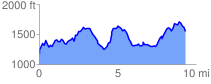
 9.704054 mi
 3223.06 ft
 2871.48 ft
 351.58 ft
 6.29 %
GPX Downloads: Track Route
![]()
| at: |
Sandy Ford |
show on map
animate
9.704054 mi
3223.06 ft
2871.48 ft
351.58 ft
6.29 %