| at: |
Coleman River Scenic Area |
Data from USFS GIS
 show on map
 animate
Trail users:

Elevation Profile
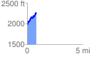
 0.813354 mi
 503.56 ft
 222.85 ft
 280.72 ft
 11.73 %
GPX Downloads: Track Route
![]()
| at: |
Coleman River Scenic Area |
show on map
animate
0.813354 mi
503.56 ft
222.85 ft
280.72 ft
11.73 %