| at: |
Warwoman WMA |
Data from USFS GIS
 show on map
 animate
Trail users:


Elevation Profile
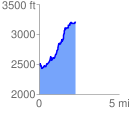
 2.264063 mi
 955.21 ft
 270.77 ft
 684.44 ft
 7.99 %
GPX Downloads: Track Route
![]()
| at: |
Warwoman WMA |
show on map
animate
2.264063 mi
955.21 ft
270.77 ft
684.44 ft
7.99 %