| at: |
Lake Burton WMA |
Data from USFS GIS
 show on map
 animate
Trail users:

Elevation Profile
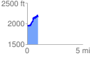
 0.977696 mi
 598.19 ft
 367.68 ft
 230.52 ft
 11.59 %
GPX Downloads: Track Route
![]()
| at: |
Lake Burton WMA |
show on map
animate
0.977696 mi
598.19 ft
367.68 ft
230.52 ft
11.59 %