|
| at: |
Rabun Beach Recreation Area |
Data from USFS GIS
 show on map
 animate
Trail users:

Elevation Profile
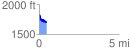
 0.474225 mi
 100.25 ft
 217.43 ft
 -117.17 ft
 8.68 %
GPX Downloads: Track Route
![]()
|
| at: |
Rabun Beach Recreation Area |
show on map
animate
0.474225 mi
100.25 ft
217.43 ft
-117.17 ft
8.68 %