| at: |
Wolf Creek Area |
Data from USFS GIS
 show on map
 animate
Trail users:

Elevation Profile
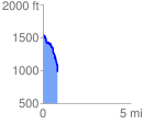
 0.850599 mi
 52.25 ft
 640.05 ft
 -587.80 ft
 14.25 %
GPX Downloads: Track Route
![]()
| at: |
Wolf Creek Area |
show on map
animate
0.850599 mi
52.25 ft
640.05 ft
-587.80 ft
14.25 %