| at: |
Wolf Creek Area |
Data from USFS GIS
 show on map
 animate
Trail users:

Elevation Profile
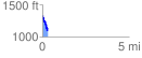
 0.301949 mi
 3.07 ft
 234.10 ft
 -231.03 ft
 14.68 %
GPX Downloads: Track Route
![]()
| at: |
Wolf Creek Area |
show on map
animate
0.301949 mi
3.07 ft
234.10 ft
-231.03 ft
14.68 %