| at: |
Lake Blue Ridge Recreation Area |
Data from USFS GIS
 show on map
 animate
Trail users:

Elevation Profile
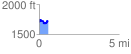
 0.558291 mi
 129.45 ft
 124.70 ft
 4.75 ft
 4.39 %
GPX Downloads: Track Route
![]()
| at: |
Lake Blue Ridge Recreation Area |
show on map
animate
0.558291 mi
129.45 ft
124.70 ft
4.75 ft
4.39 %