|
| at: |
Houston Valley |
Data from USFS GIS
 show on map
 animate
Trail users:


Elevation Profile
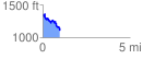
 0.981882 mi
 185.94 ft
 427.52 ft
 -241.58 ft
 8.25 %
GPX Downloads: Track Route
![]()
|
| at: |
Houston Valley |
show on map
animate
0.981882 mi
185.94 ft
427.52 ft
-241.58 ft
8.25 %