| at: |
Cohutta Wilderness |
Data from USFS GIS
 show on map
 animate
Trail users:

Elevation Profile
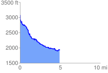
 5.002953 mi
 709.33 ft
 1918.15 ft
 -1208.82 ft
 7.26 %
GPX Downloads: Track Route
![]()
| at: |
Cohutta Wilderness |
show on map
animate
5.002953 mi
709.33 ft
1918.15 ft
-1208.82 ft
7.26 %