| at: |
Cohutta Wilderness |
Data from USFS GIS
 show on map
 animate
Trail users:

Elevation Profile
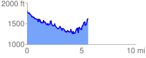
 5.686327 mi
 1900.09 ft
 2072.05 ft
 -171.97 ft
 6.90 %
GPX Downloads: Track Route
![]()
| at: |
Cohutta Wilderness |
show on map
animate
5.686327 mi
1900.09 ft
2072.05 ft
-171.97 ft
6.90 %