|
| at: |
Houston Valley |
Data from USFS GIS
 show on map
 animate
Trail users:


Elevation Profile
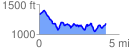
 4.246928 mi
 964.31 ft
 1109.91 ft
 -145.61 ft
 4.95 %
GPX Downloads: Track Route
![]()
|
| at: |
Houston Valley |
show on map
animate
4.246928 mi
964.31 ft
1109.91 ft
-145.61 ft
4.95 %