| at: |
Cohutta Wilderness |
Data from USFS GIS
 show on map
 animate
Trail users:


Elevation Profile
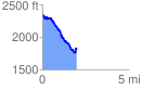
 1.964478 mi
 203.15 ft
 694.59 ft
 -491.44 ft
 6.70 %
GPX Downloads: Track Route
![]()
| at: |
Cohutta Wilderness |
show on map
animate
1.964478 mi
203.15 ft
694.59 ft
-491.44 ft
6.70 %