| at: |
Lawrence Shoals Recreation Area |
Data from David Muse
 show on map
 animate
Trail users:


Elevation Profile
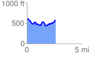
 2.642591 mi
 372.28 ft
 394.87 ft
 -22.59 ft
 2.83 %
GPX Downloads: Track Route
![]()
| at: |
Lawrence Shoals Recreation Area |
show on map
animate
2.642591 mi
372.28 ft
394.87 ft
-22.59 ft
2.83 %