| at: |
Lawrence Shoals Recreation Area |
Data from David Muse
 show on map
 animate
Trail users:


Elevation Profile
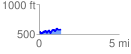
 1.388661 mi
 259.76 ft
 200.07 ft
 59.69 ft
 3.54 %
GPX Downloads: Track Route
![]()
| at: |
Lawrence Shoals Recreation Area |
show on map
animate
1.388661 mi
259.76 ft
200.07 ft
59.69 ft
3.54 %