| at: |
Rocky Mountain Recreation And Public Fishing Area |
Data from David Muse
 show on map
 animate
Trail users:

Elevation Profile
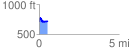
 0.527752 mi
 104.55 ft
 116.50 ft
 -11.95 ft
 4.18 %
GPX Downloads: Track Route
![]()
| at: |
Rocky Mountain Recreation And Public Fishing Area |
show on map
animate
0.527752 mi
104.55 ft
116.50 ft
-11.95 ft
4.18 %