| at: |
Buffalo Creek |
Data from David Muse
 show on map
 animate
Trail users:


Elevation Profile
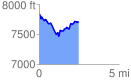
 2.451821 mi
 378.49 ft
 501.62 ft
 -123.12 ft
 3.87 %
GPX Downloads: Track Route
![]()
| at: |
Buffalo Creek |
show on map
animate
2.451821 mi
378.49 ft
501.62 ft
-123.12 ft
3.87 %