| at: |
Lawrence Shoals Recreation Area |
Data from Lush S
 show on map
 animate
Trail users:


Elevation Profile
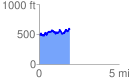
 1.912633 mi
 470.20 ft
 350.01 ft
 120.18 ft
 4.66 %
GPX Downloads: Track Route
![]()
| at: |
Lawrence Shoals Recreation Area |
show on map
animate
1.912633 mi
470.20 ft
350.01 ft
120.18 ft
4.66 %