| at: |
Lake Russell WMA |
Data from USFS GIS
 show on map
 animate
Trail users:


Elevation Profile
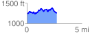
 2.737875 mi
 427.52 ft
 415.44 ft
 12.08 ft
 2.96 %
GPX Downloads: Track Route
![]()
| at: |
Lake Russell WMA |
show on map
animate
2.737875 mi
427.52 ft
415.44 ft
12.08 ft
2.96 %