| at: |
Davidson River Area |
Data from Lush S
 show on map
 animate
Trail users:


Elevation Profile
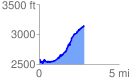
 2.849098 mi
 820.90 ft
 255.31 ft
 565.59 ft
 5.46 %
GPX Downloads: Track Route
![]()
| at: |
Davidson River Area |
show on map
animate
2.849098 mi
820.90 ft
255.31 ft
565.59 ft
5.46 %