| at: |
Breckenridge |
Data from Positive Flow
 show on map
 animate
Trail users:


Elevation Profile
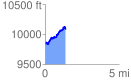
 1.380262 mi
 391.09 ft
 142.53 ft
 248.56 ft
 5.37 %
GPX Downloads: Track Route
![]()
| at: |
Breckenridge |
show on map
animate
1.380262 mi
391.09 ft
142.53 ft
248.56 ft
5.37 %