| at: |
Breckenridge |
Data from Positive Flow
 show on map
 animate
Trail users:


Elevation Profile
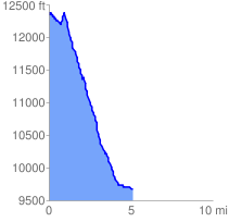
 5.267016 mi
 368.54 ft
 3061.21 ft
 -2692.67 ft
 11.01 %
GPX Downloads: Track Route
![]()
| at: |
Breckenridge |
show on map
animate
5.267016 mi
368.54 ft
3061.21 ft
-2692.67 ft
11.01 %