| at: |
Breckenridge |
Data from Positive Flow
 show on map
 animate
Trail users:


Elevation Profile
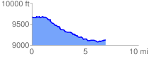
 6.953307 mi
 248.64 ft
 794.74 ft
 -546.09 ft
 2.16 %
GPX Downloads: Track Route
![]()
| at: |
Breckenridge |
show on map
animate
6.953307 mi
248.64 ft
794.74 ft
-546.09 ft
2.16 %