| at: |
Breckenridge |
Data from Positive Flow
 show on map
 animate
Trail users:


Elevation Profile
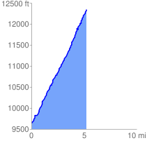
 5.295342 mi
 2757.71 ft
 65.63 ft
 2692.08 ft
 9.86 %
GPX Downloads: Track Route
![]()
| at: |
Breckenridge |
show on map
animate
5.295342 mi
2757.71 ft
65.63 ft
2692.08 ft
9.86 %